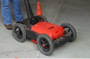
Ground-Penetrating Radar (GPR) transmits, and records reflected electromagnetic energy. The method can provide an essentially continuous image of the stream channel and the sub-bottom sediment, including the in-filled scour features.
Data Acquisition
When GPR is used over water, the antenna(s) is placed on or immediately above the surface of the water, typically in a non-conductive boat or float. Data can be acquired using a transmitter/receiver mounted in a single antenna, or by using separate transmit/receive antennas. GPR data can be acquired using different antenna frequencies varying between 25 and 2700 MHz. Lower frequency antennas provide greater penetration depths but lower resolution. Higher frequency antennas provide less depth penetration but better resolution. For waterborne GPR surveys, data is typically acquired using frequencies of 25 to 500 MHz.
Data is typically acquired at regular time intervals as the system is towed across or very slightly above the surface of the water. The system is synced with GPS for accurate horizontal positioning. GPR energy is reflected from the water bottom and other prominent dielectric interfaces (stratigraphic contacts) and returned to the receiver. The arrival time and magnitude of the reflected energy are recorded at the surface by the receiver antenna. Traces from adjacent source locations are generally plotted side-by-side to form an essentially continuous time-depth profile of the bottom and shallow sub-strata (including in-filled scour features, if present). Estimated velocities can be used to transform the time-depth profile into a depth profile. Velocities are a function of suspended sediment load and can vary appreciably.
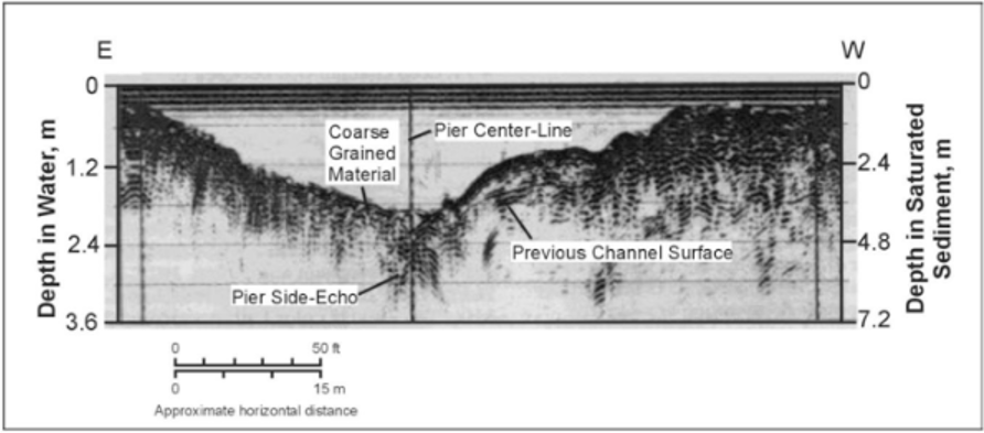
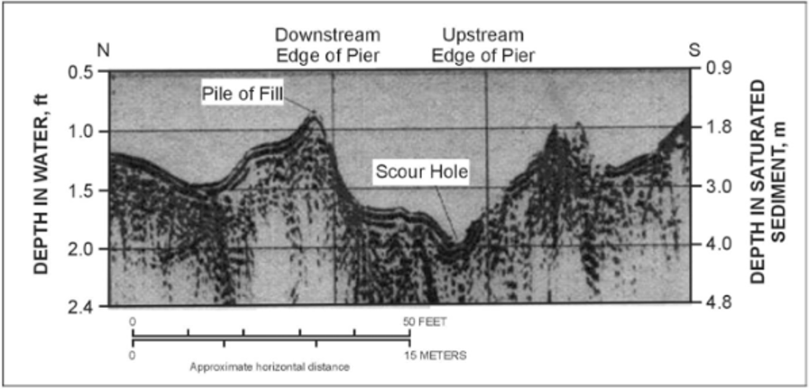
Another example of GPR data is shown above passing a pier from the downstream to the upstream side. A scour hole can be seen close to the upstream edge of the pier and a pile of fill can be seen on the downstream side of the pier.
Data Processing
GPR data can typically be viewed and interpreted without any processing. However, some processing is often desirable to improve the quality of the data, to remove unwanted noise and artifacts, and to apply depth corrections. The most common processing steps used are:
- Distance normalization
- Horizontal scaling (stacking)
- Vertical frequency filtering
- Horizontal filtering
- Velocity corrections
- Migration
- Gain
Deliverables
Results of GPR surveys are typically provided as 2D profiles showing depth corrected sections with interpreted interfaces, objects, and other pertinent features. If the survey has sufficient horizontal coverage, 3D topographic plots can be generated for surfaces identified in the profiles.
Advantages
GPR surveys are non-invasive, and data can be acquired quickly, providing a very high data density at a relatively low cost. The GPR antenna does not need to be physically coupled to the water surface and can be operated remotely if required, ensuring that neither the operator nor equipment need be endangered by floodwater. Profiles can be extended across sand bars or onto the shore for continuous coverage over large areas.
GPR can provide a reasonably accurate depth-structure model of the water bottom and sub-bottom sediments up to 10m. Post acquisition processing can be applied to the data to improve the vertical and horizonal resolution of the data allowing for the interpretation of relatively thin beds.
Limitations
The main limitations of the GPR method for this application are that the data may be contaminated by noise (multiple reflections and echoes from pier footings and other off-line structures. The method is typically not effective when water depths exceed about 10m, where there is a high sediment load in the water, or in conductive water (brackish, saline, or contaminated).