The seismic refraction method can be used for investigating voids or sinkholes in the subsurface. Since seismic velocities are strongly controlled by material stiffness, zones affected by voids or sinkhole processes often produce measurable velocity anomalies.
In intact bedrock or well-compacted soils, seismic velocities are relatively high. In contrast, materials that are loose, highly fractured, weathered, or partially unsupported tend to transmit seismic energy more slowly.
The method is most effective when the suspected features are shallow and of sufficient size to influence seismic wave propagation. In many engineering and environmental studies, this means targets within the upper tens of meters of the subsurface and with dimensions large enough to be resolved by the geophone spacing and survey geometry. Seismic Refraction Tomography (SRT) is particularly useful in karst environments, where sinkholes commonly develop above zones of dissolution and weakening in carbonate bedrock. In such settings, the technique can help delineate zones of reduced competency and irregular bedrock surfaces that are associated with sinkhole hazard.
Data Acquisition
The design of the survey is the similar to any other seismic refraction survey although typically more shot points are used to generate more raypaths for tomographic processing. The length of the geophone spread, or the size of the geophone grid should be sufficient to image features of interest. Geophone spacing should be based on the resolution needed. Depending on the depth of investigation, an energy source of sufficient size is required. Since soft materials associated with underground voiding may attenuate the signals more than well-compacted materials and solid rock, more energy may be needed than an equivalent survey of competent material. 3D surveys may be beneficial at sites with complex geology and target geometry.
Data Processing
Data processing is the same as for any other seismic refraction survey. Data processing using SRT is often advantageous over other processing methods due to the complex target geometry.
Data Interpretation
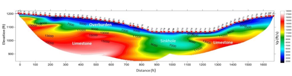
A void or a developing sinkhole is commonly expressed in seismic refraction data as a localized low-velocity zone, a vertical or lateral disruption in otherwise continuous velocity layers, or as sagging of velocity contours in SRT models.
Deliverables
Results of seismic refraction surveys for sinkholes and voids are typically provided as 2D or 3D plots of seismic velocity variations using SRT. Interpretation of the data for voids and sinkholes involves mapping the lateral and vertical extent of the target features. An example of a 2D SRT profile over a large sinkhole is shown in the figure below.
Advantages
An important advantage of seismic refraction tomography over other geophysical methods is that seismic velocities are controlled by how rigid, competent, and well-cemented a material is. Therefore, in certain situations, seismic refraction tomography can provide information about how the subsurface will actually behave under load. This makes it particularly valuable in engineering and sinkhole-hazard studies where the key concern is not just whether a void exists, but to what extent it may affect the built environment.
Limitations
Seismic refraction has inherent limitations when applied to void detection. One of the most important is that refraction methods work best when seismic velocity increases with depth. Void-related environments often violate this assumption. When low-velocity features underlie more competent material, they may be impossible to image.
In addition, low-velocity anomalies are non-unique: soft soils, highly fractured rock, and true cavities can all produce similar seismic responses. As a result, seismic refraction alone cannot in many cases reliably distinguish between these different subsurface conditions. However, when combined with methods that respond to different physical properties, such as electrical resistivity or gravity surveys, the interpretation becomes much more robust. While seismic refraction is sensitive to stiffness and elastic properties, resistivity methods respond strongly to moisture content and void space, and gravity methods respond directly to density contrasts. Together, these approaches can significantly reduce ambiguity. Ground truthing through boreholes, cone penetration testing, or test excavations is still essential when confirming the presence and nature of voids or sinkhole features.